In spite of my qualms about becoming a disaster gawker in Ishinomaki, I realized that to get a real appreciation of the scale of the destruction I would have to get a first hand look. I figured the best way to do so would be to find a road that led straight for the coast, taking me through the area inundated by the tsunami. Doing so would allow me to observe what the water had done at various depths, from areas that had only been shallowly covered at the start to those that had born the brunt of the tsunami’s full force, as well as the subsequent rip current as the water pulled back into the sea. For this purpose, the disaster survey map that I bought in Sendai on the first day in town – the same one from which I took the map of Ishinomaki in the last post – came in handy. The long coastline that stretches from the eastern side of Sendai south provided plenty of likely sites; here the water rolled unopposed for kilometers across low-lying plains of rice paddies, fields, farmers’ homes, and suburban housing developments.

(Source: 『東日本大震災復興支援地図』Mapple昭文社、2011年7月、第22図)
I soon found the ideal entry point: Tategoshi Station, on the Tohoku Main rail line, in Natori City. As you can see on the map above, Tategoshi Station (circled) stands just across Route 4 (the pink line) from where the water came to a halt. There is no other station on the line as close to the tsunami zone as this. My plan was to head south on Route 4 to where it intersects with Route 20 (in green), and then walk eastward along Route 20 to the coast. If possible, I wanted to make it all the way to the water’s edge.
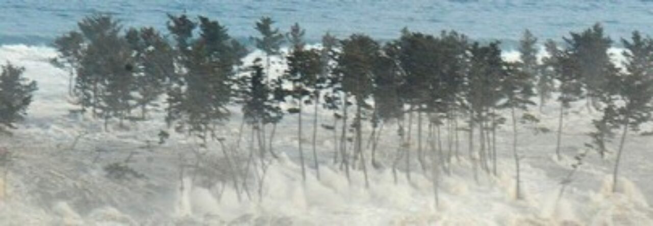
This area was particularly hard hit by the tsunami. In the confusing days immediately following March 11, roughly half of the population of Natori was unaccounted for. Nearly one-thousand lost their lives in Natori, out of a pre-tsunami population of about 74 thousand. The city’s home page still lists several of the bodies recovered as unidentified. The neighboring town of Iwanuma faired just as poorly. The waves along this portion of the coast are estimated to have reached 12 meters in height. The banner shot I use for this blog, showing the tsunami crashing through a line of pine trees along the coast, was taken in this area, and I imagined that my route would take me very close to the exact spot.
What follows is a series of photos taken along the way, in the order that I encountered the scenes in them.

Approximately 5.5km from the ocean: The side of Route 20 has a nice walking path – or did at one point, anyway. I’m not sure if the weeds are due to the tsunami or just neglect. It’s easy to imagine how the town wouldn’t be able to keep up with such routine maintenance at a time like this.

The fields in this area were not planted with crops this spring, because of salination from the ocean water. It is apparently very difficult to desalinate soil, and the work of returning the soil in all the stricken areas to its pre-tsunami condition may take years. Weeds seem to do just fine in the stuff, though.


Approx. 5km to the shore: The first pile of battered cars I came across. This appeared to be a temporary collection area. I crossed a line of orange cones to take this picture and as soon as I did out of the corner of my eye I saw security guard running toward me in the distance, making a big “X” over his head with the two batons he was holding – the universal sign for “not permitted.” I got the first shot off and left before he could get near enough to verbally shoo me away. The second was taken for the other side of the stream that runs along the walking path. I found it odd that a pile of battered cars would be guarded, but I suppose unscrupulous individuals might try to salvage them for parts.


Less than two hundred meters later, I came upon another collection area, for cars and other gareki. These were the first mounds of rubble I found. The rusted autos in the foreground were probably incinerated in the fires that ironically broke out in the midst of the tsunami. The debris appeared to be a mixture of wood, sand and sludge churned up by the tsunami, and miscellaneous trash. It has sprouted a healthy covering of weeds. By the end of the summer, it may blend completely into the greenery around it. Such piles may become the kofun burial mounds of the Heisei period.

Approx. 4km from the ocean: This pile of debris stood along the bank of the stream I was following to the coast. From this point on, rubble piles like this lined the stream fairly consistently. Also, the fact that this was un-separated trash, unlike the piles of classified and selected trash elsewhere, suggests that natural forces may have piled this stuff up. Could it be that the tsunami channeled this stuff down the narrow stream, piling it up on either side as it went?
Debris is not just being left to rust and rot. A bit further on, I came upon a scrap-recycling factory that had plenty of business. I was struck not only by the size of the pile – at least 30 feet high – but even more so by the fact that most of what is in it is practically unrecognizable.


Japan recycles 96% of its trash. Especially in a country with very little land to use for landfill, this just makes sense. Processing all of the scrap of various kinds produced by this disaster will take time, but the technology is available to do the job. The main problem is coordinating the efforts to take care of it all, which will require supervision on the national level. At present, however, local municipalities are handling most of the planning themselves. Much of the criticism of the central government’s handling of the disaster focuses on this lack of coordination at the top.
Route 20 eventually leads to Sendai Airport (on the border between Natori and Iwanuma). It is lined more with businesses than homes, most of which were still closed and showed signs of damage from the tsunami. I did see signs of recovery, though. About 2.5km from the ocean, I came upon a soba restaurant that had just reopened on July 18.

In hindsight I should have dropped in for a bowl of soba and a chat, but I wasn’t hungry and by this point wholly focused on finishing the trek to the sea.
A half-kilometer further, I came upon this:

This statue stood in front of a stone and masonry workshop. These are three stylized jizo. Jizo are Bodhisattvas of compassion that are something like the patron saints of children in Japan. The “ganbarō Miyagi” sign appears again, but in the present setting the reason to “hang in there” is readily apparent.
These and other signs of resurgence were welcome. In the midst of the debris, even finding a 7-11 or a Lawson open for business is reassuring, and there were a few along the way.
By the time I reached the 2km mark, though, signs of the devastation were more common than signs of our everyday world reasserting itself. At 1.5km, I began to come across buildings like this:

And then, half a kilometer of so further, this:

The “x” marks were the shorthand search and rescue teams used to tell others that no bodies had been found inside. I was surprised to still see them on buildings four and a half months after the tsunami. This suggests that nothing has been done to these buildings since.
At around the same point, I began to notice scenes like this:

Straw, seaweed, and other debris still caught in a fence, four months on, and still suggesting the direction of the current that brought it all there.
I don’t know how high the water or how strong the current must have been at this distance from the shore, but just judging from the damage I saw to the buildings in the area, I would image that it was at least two meters high. In spite of this, some of the rubble I found was still surprisingly intact.

These appear to be fixtures from a temple or perhaps a funeral hall, found about 1km from the ocean. Most likely they were dumped here after being removed from a damaged building. The clean-up effort, by the way, appears to have made quite a bit of progress, despite the piles of debris. I saw very little evidence of sand and sludge on the street or sidewalk.
 At this point, Route 20 turned to the left in the direction of the airport. To the east of it ran a shallow canal that separated the area I had just walked through from an area that looked like in must have been residential. I say “looked like” because aside from one or two badly damaged homes on the other side of the canal, there wasn’t much left to tell what had been there before. A constant line of dump trucks crossed a small bridge over the canal, carrying concrete, wood, and other debris out of the area – what had probably once been a neighborhood. The canal is only about 750 meters from the ocean. I thought of trying to squeeze my way past the trucks to cross the bridge, but thought better of it when I saw a barrier on the other side patrolled by someone wearing a helmet and looking official – whether it was an actual police officer or not, I couldn’t tell at a distance. As with the junk cars, there are concerns about people going souvenir hunting in the houses that are left standing. Giving up on crossing the canal here, I took a shot of one of the houses on the other side and headed on in search of another crossing point.


In spite of the tsunami, it is incredible how life, at least plant life, has made a comeback. Many of the uncultivated, salinated fields and paddies I had passed were verdant with weeds. And here, a mere 750 meters from the ocean, nature was once again trying to overwhelm the work of human beings, this time with life rather than death.
At 750 meters, our creations weren’t doing so well, however:


This was the view looking across the canal again, at a point a bit closer to the airport. This area used to be full of homes and parking lots for customers flying out of Sendai. It’s hard to get a sense of how much has been swept away without knowing what was there before. Maybe Google Earth can help provide a sense of it. Here’s the way this area looks in the satellite photo taken on April 6, 2011:

If anything, the area is even more desolate today, since the city has been tearing down the structures that are structurally compromised beyond repair.
And for contrast, here’s the way the same area looked back on August 14, 2009:

As I approached the bridge over the canal in these photos, I contemplated crossing. There were hardly any trucks crossing at this point, perhaps a sign that the work was mostly done. I saw another guy wearing a helmet standing on the bridge, but as I sauntered toward him trying to look nonchalant, he just as nonchalantly abandoned his post and walked on toward the airport.
As I surmised, much of the work of clearing and salvage had been completed. With the exception of a few structures still miraculously standing, the other side of the bridge is a barren landscape. The ground is strangely soft, as if it is covered in a fine pumice-like substance, finer than sand. When I stepped off of the pavement, I left footprints and inch deep in the ground.

A small, impromptu shrine to the souls of those who lost their lives here, especially the children.

In spite of the clearing of the land, personal objects of the people who used to live here remain. Above, a junior high school student’s bicycle helmet. Below, a “Hello Kitty” bag among the weeds.

A small Shinto shrine amongst a clump of trees remains, damaged but still intact.


One of the few structure left standing around the bridge. That this house, at a mere 200 meters from the ocean, remains standing at all is something of a miracle. It was gutted by the tsunami and will most likely be torn down soon, but its very existence seems like a monument to both human hubris (building so close to the ocean in a land plagued by earthquakes and tsunamis) and human fortitude.
The road to the ocean ran right by this house, but as I walked down it, I saw yet another barrier with signs saying “entry prohibited,” and yet another helmeted guard giving me the “x” sign. I approach him and asked if there was any way to get onto the beach. Not around here, was the answer. Apparently, on the other side of the trees crews are still busy with cleaning up the beach and dragging debris out of the water that was swept in when the waves pulled back with almost as much force as they had rolled in with. There’s also the concern that they may still find human remains there. I asked if they were still finding bodies at this point.
“Parts of them, sometimes, but a lot less often in this area since the large debris has been removed.” It was a strikingly matter-of-fact answer to what I realized at that moment had been a strikingly insensitive question.
 I headed back across the canal to visit the airport, which has reopened for domestic flights and will soon be open for international flights as well. The first floor arrival lobby, which was completely submerged, is still being repaired. In fact, I saw more workers than passengers around the arrivals area.
In better days there was train service right to the front of the airport, but that too was damaged by the tsunami. Instead, I boarded a bus to the next station up the line, from which the trains back to Sendai were running. The bus took a route through the area on the other side of the bridge I had just walked around in, before heading west over the canal. I took the footage below from the window. Bear in mind again how full of houses, parking lots, and other structures this area was before March 11. Now that the gareki has been largely removed, it seems even more desolate, but evidence of the buildings that once stood here can still be seen. At around the 1:40 mark you’ll see what looks like thickets of gray stalks of some sort of plant, bent over by the tsunami. These are actually rebar rods from concrete that used to stand here. You can also see plenty of standing water. It’s unlikely that this was left since the tsunami, but the fact that there is standing water still, in spite of there having been no rain here for days, suggests how waterlogged the ground is.
Watari
The next day, I accompanied Hariu-san and his wife to Watari, on the coast about 10 kilometers south of Natori. The waves here were just as high as in Natori, but because the area was even more built up than the coast near the airport, the clearing work has made less progress. Here too, to get a sense of how damaging the tsunami was, it helps to have a sense of what was there before. Again to Google Earth for the before and after shot:


I only took video from the car window on this trip. The clip is long – about 13 minutes – but I think it gives you a sense of how the destruction gets worse and worse as we traveled toward the area at the center of the satellite images above. A particular landmark is the school building – Arahama Junior High – which stands in the upper left-hand part of the photos. Although this building still stands, it will have to be torn down due to subsidence of the ground beneath it. You can see in the video that the roofline slopes a bit to the right side of the screen. Also worth noting are the mountains of rubble, divided into categories, standing in the distance. These are at least 40 feet high.
Although the entire area in this clip was inundated, the destruction becomes most evident from the 1:45 mark on, as we travel into the area of Watari closest to the coast.
That will do it for this time. Tomorrow I’m off to Ishinomaki to do volunteer work in the Watanoha area of the city with the Japan Emergency Network. It will probably be a few days before my next post.