Unequal Schools searchable maps by CT Voices

Posted on

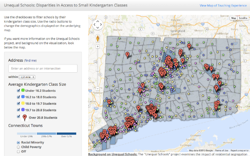
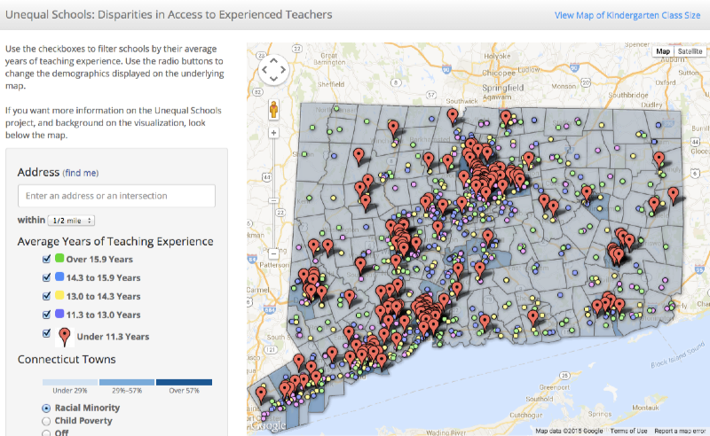
Connecticut Voices for Children, a non-profit research and advocacy organization, published a new report, Unequal Schools: Connecticut’s Racial, Socioeconomic, and Geographic Disparities in Kindergarten Class Size and Teaching Experience. Their study reveals how low-income students and students of color are more likely to attend public schools with large kindergarten class sizes, and employ the least experienced teachers in Connecticut. These unequal educational resources are linked to the state’s long-standing patterns of residentially segregated housing.

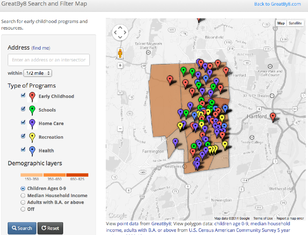
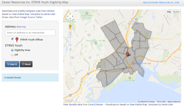
When CT Voices co-authors Kenneth Feder and Sarah Iverson visited Trinity College to discuss their draft report, they asked for advice on how to communicate their findings with the public. Trinity College student Veronica Armendariz ’16, an Educational Studies major and student researcher in the Data Visualization project, recommended placing school inequality and town racial data in a searchable map, so that viewers can see statewide patterns and also zoom into specific neighborhoods. Veronica worked with CT Voices and taught them how to create their own searchable maps with Google Fusion Tables, using an open-source template developed by Derek Eder in Chicago. Click on both of the maps to explore the data.

Click map to explore CT Voices - Unequal Schools - kindergarten class size
Click map to explore CT Voices – Unequal Schools – kindergarten class size
Click map to explore CT Voices - Unequal Schools - teacher experience
Click map to explore CT Voices – Unequal Schools – teacher experience


Designing a school search tool with Achieve Hartford

Posted on

In summer 2014 we collaborated with Achieve Hartford to design a school search tool that shows city parents their eligible public school choices. Our goal is to replace the existing SmartChoices site, which Trinity created in 2008, with a simpler tool that’s easier for a small non-profit organization to maintain on their own. To accomplish this task, we turned to Google Fusion Tables and the Searchable Map Template created by Derek Eder at DataMade in Chicago. Derek worked with us to expand his open-source code (available on GitHub) to display a sortable table of results in addition to the interactive map. It’s a responsive design, meaning that it adjusts the display to fit the size of your device, such as tablets and smartphones. Learn more about the background of this project and explore the beta version of SmarterHartford.org (which will be publicly launched soon).

Cick to explore the beta version of SmarterHartford.org.
Click to explore the beta version of SmarterHartford.org.


Affordability and Transit Map by Partnership for Strong Communities

Posted on

Diana Deng from the Partnership for Strong Communities created this interactive map of housing affordability and mass transit, based on guidance provided by Veronica Armendariz and the DataViz team at Trinity College. This map draws data from an easy-to-maintain Google Fusion Table, and the interactive map platform runs on an open-access code template created by Derek Eder at DataMade in Chicago. Learn more about the map and explore it on the Partership’s site at: http://pschousing.org/news/new-partnership-map-allows-users-explore-connections-among-housing-transit-and-population

Click to explore the map in a new tab/window.

GreatBy8 School Map

Posted on

Greatby8

Great By 8 is a community collaborative focused on improving access to high quality services in the areas of early childhood education and health in the West Hartford area.

For GreatBy8, we created an interactive map that is able to allow users to look up their addresses in West Hartford and find different resources (such as schools, early childhood programs, health programs, and other programs) as well as seeing the demographics in each of their individual census tracts. Within each of the census tracts users are able to see the number of children 0-9, median household incomes, and percentage of adults with a bachelor’s degree and above. To see the different schools, early childhood centers, and resources around you as well as other demographics according to your own census area, type in your address here.

Click to explore GreatBy8 interactive map.

Career Resources Inc. STRIVE Eligibility Map

Posted on

CAREER_RESOURCES_INC_Career Resources, Inc. provides youth and adults throughout Connecticut the skills, resources and support necessary for personal development, economic self-sufficiency and career advancement, and provides planning and staffing resources to the business community in support of workforce development and economic growth.

They have two main offices for the STRIVE program in the cities of Hartford and Bridgeport and have certain eligibility areas within each city. Users are able to enter in their address and see if their census area is within the eligibility area for the STRIVE program. To find out if you’re eligible, see interactive map here.

Click to explore Career Resources map in a new tab/window.