GreatBy8 School Map

Posted on

Greatby8

Great By 8 is a community collaborative focused on improving access to high quality services in the areas of early childhood education and health in the West Hartford area.

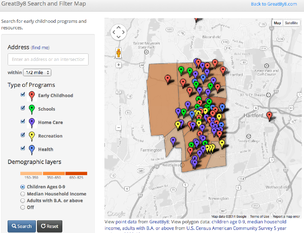
For GreatBy8, we created an interactive map that is able to allow users to look up their addresses in West Hartford and find different resources (such as schools, early childhood programs, health programs, and other programs) as well as seeing the demographics in each of their individual census tracts. Within each of the census tracts users are able to see the number of children 0-9, median household incomes, and percentage of adults with a bachelor’s degree and above. To see the different schools, early childhood centers, and resources around you as well as other demographics according to your own census area, type in your address here.

Click to explore GreatBy8 interactive map.

Transition Plan

Posted on

The data I used to create my visualization was simply found on the internet. These useful locations and points in West Hartford can be changed and others can be added or removed. The goal and intention was simply to find useful resources for children 8 and under. This visualization show’s these location in the West Hartford boundary.

I imagine a map such as mine can be used or maps that are specifically used for solely one of the types of locations. Such as a map of only day cares or dental care.

I first used google fusion tables that can be located through this link.

Polygon data

Point data

And finally I used github to create the two layer map, that can be found here.

Greatby8: The easy way to find early childhood resources

Posted on

Throughout my semester of data visualization I worked with the partnership named Great by 8. Great by 8 “is a community collaborative focused on improving access to high quality services in the areas of early childhood education and health. Great by 8 is a combined Graustein Discovery Community Board and the Town of West Hartford’s School Readiness Council. [They] have a formal board comprised of parents, teachers, public school administrators, private program directors and other community members to ensure that all West Hartford children are Great by age 8.”

In my data visualization I used a polygon outline of West Hartford and found useful locations to place on the polygon layer. The useful locations are there in order to make finding resources, such as health care units, dental care, recreational facilities, day cares, clothing stores etc. for children 8 years and under, easy to find and more widely known.

Click here to access my data visualization.