Archive for the ‘From the stacks!’ Category

img863In a humble little volume with the spine title “Collection of Pamphlets” (volume 14), bound with six other unrelated titles, is The Journal of Major George Washington sent by the Hon. Robert Dinwiddie, Esq; His Majesty’s Lieutenant-Governor, and Commander in Chief of Virginia, to the Commandant of the French Forces on Ohio . . . with A New Map of the Country as far as the Mississippi.

Intitially printed in Williamsburg in 1754 (of which there are only seven (7) copies reported in institutional libraries), ours is a copy of the London reprint of the same year, held by thirty (30) other libraries. Washington’s fame at home and abroad begins with this pamphlet.

“In the early part of the 1750s French and English forces were expanding into the Ohio Valley, both forming alliances with Indian tribes and setting up trading encampments. In 1753 the French took possession of a tract of land within the chartered limits of Virginia. They then proceeded to erect a chain of military posts from Canada to the Ohio River. All the while, French soldiers and traders made their way up from the south and down from the north, taking possession of the Ohio country. The French encroachments on the English settlements forced Virginia Governor Robert Dinwiddie to send a commission to warn the French to halt their advances. However, the commission stopped 150 miles short of the French posts and turned back after witnessing the slaughter and defeat of the Indians by the French.

WashingtonAn officer in the Virginia forces — Major George Washington — was recommended to Dinwiddie as an up-and-coming light, someone who might accomplish the mission. Although only 21 years old, Washington was appointed by Dinwiddie to go into the Ohio Valley and deliver a letter to the commander of the French forces, warning him against their actions in violating British rule over those lands. In addition, Washington was to observe French activity and enforcements, and make friends with the Indian tribes.

On October 31, 1753 Major Washington set out from Williamsburg with a small band of men experienced in the ways of the wilderness. The group consisted of Jacob Van Braam, a Dutch soldier of fortune and French interpreter; Christopher Gist, a Virginia frontiersman of great renown; two servitors; two Indian traders and accompanying horses. During Washington’s 78 days in the wilderness he met with chiefs of the Indian nations and delivered Gov. Dinwiddie’s letter to the French Commandant, LeGardour de St. Pierre. In a private meeting with Major Washington the French Commandant refused to back down.

On their return to Williamsburg Washington’s entourage encountered bitter cold, deep snow, ice and freezing rain. At one point Washington writes in his Journal “…our horses were now so weak and feeble, and the baggage heavy….therefore myself and others gave up our horses for packs…”  Washington disguised himself in Indian dress while he and Gist decided to return alone on foot. While traveling through the woods they ran into an ambush of French Indians. One of the Indians…”not 15 steps away”… fired at the pair but missed. While crossing a turbulent river on a homemade raft, Washington was thrown off into 10 feet of water. The weather was so severe, he writes in his Journal, “that Mr. Gist had all his fingers, and some of his toes frozen.”

Washington returned to Williamsburg on January 16, 1754. He spent the entire next day writing his account from the entries he had made during the course of the trip. The following day — January 18 — his Journal was presented to the Virginia Assembly which immediately raised a regiment of 300 men to defend their frontiers and maintain England’s rights over the disputed territory.”

Quoted from http://www.earlyamerica.com/earlyamerica/milestones/journal/

1
Oct

Trinidad/Tobago

   Posted by: rring

I celebrate the 250th post to this blog with a note that we have some great early Caribbean resources, which can relate not only to academic work on campus, but real-world cultural studies, like the “Trinity-in-Trinidad” program.

tobago0001

Relation de L’Isle de Tabago (Paris, 1666).  Charles de Rochefort (1605–1682) dedicated this work to three men who formed a project to encourage settlers in the island of Tobago.  They had transported a number there under the auspices of the States-General of the Netherlands, and this work was intended as a guide for settlers—giving details of the customs of the indigenous people, climate, and the island’s potential for production (including sugar cane, ginger, and especially tobacco).

As you can see from both of these works, the Dutch and the English (not to mention the French) were hugely interested in developing colonies in the Caribbean, in order to compete with the Spanish and the Portuguese imperial projects which had been in operation for well over a century by the time these two works were published.


tobago0002

The Present Prospect of the Famous and Fertile Island of Tobago (London, 1695).  In 1681, four ships commanded by John Poyntz (1629-1712) captured a Dutch settlement on Tobago.  In 1681, he obtained 120,000 acres on the island on behalf of a group of merchants, and two years later he published this pamphlet promoting the benefits of the island as a place to settle.  This “very well informed survey” (Oxford DNB) describes the climate, flora, fauna, and timber of the island, and prospects for growing cocoa, sugar-cane, and tobacco.  Several hundred settlers from Barbados moved to Tobago, but the king blocked Poyntz’s project and they were returned to Barbados.

23
Sep

Early, scarce map of NYC

   Posted by: rring

As a curator, keeping one eye on the rare book trade not only means that I see possible opportunities for acquisition–it also serves to focus attention on overlooked items. Here is my most recent “re-discovery.”

John Randel, The City of New York as laid out by the Commissioners with the Surrounding Countryside (New York, 1821).

A copy of this map recently came up for auction in New York, and although the one for sale was printed on satin (and is therefore much more valuable on the collector’s market), ours is still a scarce and important copy (one of only two or three known). We have contracted with a conservator to address some condition issues, to ensure this map can be used and displayed. Here are “before and after” pics–our conservator, Sarah Dove, worked miracles!

NYC Map B_A-1

Here is excerpted text from the lot description (Swann Auction Galleries):

As New York City entered the 19th century, It became clear that plans for its expansion northward were in order. The narrow streets from the early Dutch and English settlers could no longer handle the increasing population. This was coupled with an increase in disease spawned by the close quarters of the city at that date.

In 1807 the Common Council of the city petitioned the State Legislature to create a Board of Commissioners to oversee the laying out of a future street system. The board was created and mandated to finalize its plans within a four year period. Governor Morris, Simeon de Witt, and John Rutherford became the commissioners. Simeon de Witt had been the Surveyor General for the state and had become impressed with the work of one of the surveyors under his charge, namely John Randel.

Randel was hired as chief engineer and surveyor for city. He began his work soon after. Though Manhattan Island was hardly a wilderness, it contained 60 miles of running streams, around 20 ponds and lakes, as well as hills, valleys and plateaus. With some surveying instruments of his own devise, Randel set to work. The difficulties of topography were not the only obstacles he was to encounter. Free-holders and lease-holders on the land being surveyed were fearful of losing their land and their rights. Randel was arrested a number of times for trespassing, and just as many times released on the order of the City Council.

Randel finished his project a bit ahead of schedule. The survey overlaid with the now famous grid street plan was ordered to be prepared for publication under the direction of William Bridges. Peter Maverick, the well known engraver, was chosen to engrave the map. The map map appeared in 1811 (Haskell 651) and is based almost entirely on the survey conducted by Randel, with some additions by Bridges. Randel’s name did not appear on the map. Thus began a long and acrimonious relationship between Randel and Bridges. Randel claimed that Bridges had not copied his survey faithfully and that it was full of errors. Randel took charge of the survey and embellished it further. He was set to have it published in 1814 but decided against it -the British had recently burned Washington and Randel feared his map would be too great an aid to the enemy should they decide to attack the city. The manuscript copy of the Randel embellishment is currently under the protection of the New York Historical Society.

In 1821 the finalized version of the map appeared under Randel’s name (his name appears 3 times on the map). The grid system begins with 1st street and runs northward to 155th street with the streets running from east to west. It is intersected by 12 avenues running from south to north. It is the grid which modern day inhabitants and the city’s many visitors have come to count on for easy navigation of the metropolis.

The Randel map was printed on paper and a very few seem to have been printed on satin. The only other existing copy on satin that we can locate is held by the New York Public Library, gifted by the well-known New York iconographer I. N. Phelps Stokes, who had acquired it from Randel’s nephew.  Two paper copies are known.

In addition to the great importance this map bears in its relationship to the mapping of the city, it is a beautiful map to behold. In addition to the grid plan for New York City, there are incorporated maps of parts of Connecticut and Rhode Island as well as an inset of the city of Philadelphia. These are neatly overlaid on one another and with a trompe l’oeil effect they appear to roll in upon themselves.

For the fullest and most succinct history of the evolution of the map, Augustyn and Cohen’s Manhattan in Maps should be consulted.


3
Jun

Great chemistry!

   Posted by: rring

Here’s a great example of what you can find just browsing.  Looking for a patron at what we had on chemistry, I came across a four-volume set of manuscript notes (possibly by a professional copyist) with the title-page “Lectures on Chemistry by Joseph Black, M.D., Edinburgh 1786-7.”  It seems that we have a fair copy of Black’s lecture notes, taken by William P. Maxwell, one of his students.  Apparently many copies of manuscript notes on Black’s lectures, taken by his students, were in circulation at the time–some of which were better than others.  According to one source:

“Joseph Black (1728-1799) was Professor of Chemistry at the Universities of Glasgow (1756-66) and Edinburgh (1766-99). Immediately after his death, his executors decided to publish his lectures from his manuscript notes.  This step was taken as they were informed that publication was proposed from notes taken by his students . . . The best of these was considered so unworthy of Black that the executors wished to prevent the inadequate impression of his knowledge and talents which such a publication would make.”

John Robinson, Professor of Natural Philosophy at Edinburgh and a former student of Black, was chosen to compile and edit the lectures, which were published in 1803.  We have in the Watkinson the first American edition (Philadelphia, 1807), which (interestingly) contains a list of 138 named subscribers, who ordered 528 copies, all told (the largest order by far was from Birch & Small, 200 copies). Another factoid of interest is that this copy was formerly owned by George Brinley, Jr. (1817-1875), the great Americana collector, who was a founding Trustee and second President of the Watkinson Library (75 years before it came to Trinity College).  Brinley gave this set to Trinity in 1842.

It might be a fascinating project for a student to compare our copy of the lecture notes with the published version, as a book history project.

Sources:

“Joseph Black’s Lectures on the Elements of Chemistry” Isis 25:2 (Sept. 1936), 372-90

I saw the following description of a book for sale in the trade and discovered to my relief that we had a copy!
Francis Douce (1757-1834) was the youngest son of a lawyer, who (much to his father’s dismay) was only interested in literary and antiquarian research, not a profession in law.  According to the DNB, “He succeeded to a smaller share of his father’s property than he had anticipated, and attributed his disappointment to the ‘misrepresentation’ of his elder brother, ‘who used to say it was no use to leave me money, for I should waste it on books.'”
Illustrations of Shakespeare, and of ancient manners: With dissertations of the clowns and fools of Shakspeare; on the collection of popular tales entitled Gesta romanorum; and on the English morris dance. London, 1807.
This is Douce’s commentary on obscure points of Shakespeare’s plays, examining possible source materials and often focusing on the anachronisms present in the plots and settings. Includes the legalities of different types of marriage contracts, the nature of period music (offering as examples tunes for the “Scotish brawl” and “Canary”), and the fine details of such activities as quail fighting, crow keeping, wassail drinking, wearing chopines, furnishing funeral tables, etc., as well as longer researches on the subjects described in the title. The work was generally well-received at the time of its publication, and a later 19th-century critic praised Douce for his “delicate and sympathetic apprehension of the peculiar beauties of Shakespeare,” but Jeffrey rather famously severely critiqued the work in the Edinburgh Review, and Stapfer described it as “bristling with erudition but devoid of talent, and very foolish and irreverent towards Shakespeare.”
Two examples of his topics follow:
O beat away the busy meddling fiend / That lays strong siege unto this wretch’s soul.
[King Henry VI, part 2, Act III, scene 3]
“It was the belief of our pious ancestors, that when a man was on his death-bed the devil or his agents attended in the hope of getting possession of the soul, if it should happen that the party died without receiving the sacrament of the Eucharist, or without confessing his sins.  Accordingly in the ancient representations of this subject, and more particularly in those which occur in such printed services of the church as contain the vigils or office of the dead, these busy, meddling fiends appear, and with great anxiety besiege the dying man; but on the approach of the priest and his attendants, they betray symptoms of horrible despair at their impending discomfiture.  In an ancient manuscript book of devotions, written in the reign of Henry the Sixth, there is a prayer addressed to Saint George, with the following very singular passage: ‘Judge for me whan the moste hedyous and damnable dragons of helle shall be redy to take my poore soule and engloute it in to theyr infernall belyes.'”
In his section “On the clowns and fools of Shakespeare,” Douce creates a classification of nine (9) types, including:
I. The general domestic fool, often, but as it should seem improperly, termed a clown.  He was 1. a mere natural, or idiot. 2. Silly by nature, yet cunning and sarcastical. 3. Artificial
II. The clown, who was 1. a mere country booby. 2. A witty rustic. 3. Any servant of a shrewd and witty disposition.
III. The female fool, who was generally an idiot.
IV. The city or corporation fool, whose office was to assist at public entertainments and pageants.
V. Tavern fools. These seem to have been retained to amuse the customers.
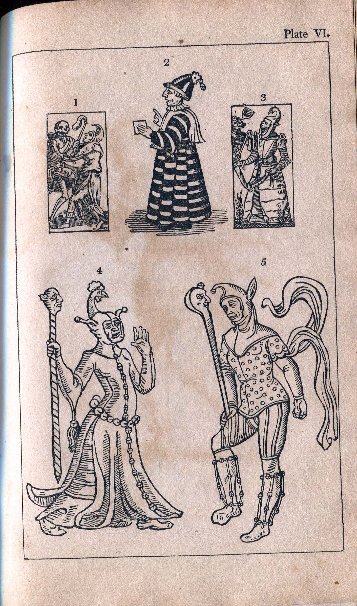
“Plate VI: Fig. 1 and 3 are from A booke of Christian prayers, &c., 1590, being figures belonging to a dance of Death.  Fig. 2, is from the frontispiece to Heywood’s comedy of The fair maid of the exchange.  Similar figures of the costume of fools in the time of James I., or Charles I., may be seen in the Life of Will Summers, compiled long after his time.  Fig. 4 and 5 are from La grant danse Macabre, printed at Troyes without a date, but about the year 1500, in folio, a book of uncommon rarity and curiosity.”